| View previous topic :: View next topic |
| Author |
Message |
atrexontheboat
Joined: 01 Sep 2014
Posts: 12
Location: Canton, CT
|
 Posted: Sat Sep 06, 2014 9:26 pm Post subject: Conn. River Report from 9/4/14 Posted: Sat Sep 06, 2014 9:26 pm Post subject: Conn. River Report from 9/4/14 |
 |
|
ok so we headed out of the Riverside launch in Hartford and went as far as we could before we were in three ft. of water, just past the Bissell bridge. Couldn't quite get to the mouth of the Farmington river. Decided to turn around and fish the way back to the launch. Very shallow! We have a flat bottom Tracker and it was touchy. Anyway, we slammed the Smallies with Yum Dingers on a drop shot rigs. Plan on going again this week but heading south for deeper water. Did I mention SHALLOW?[img][/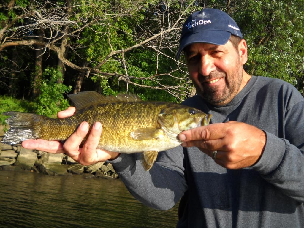 img] img]
Last edited by atrexontheboat on Fri Sep 26, 2014 3:16 pm; edited 1 time in total |
|
| Back to top |
|
|
|
PECo
Joined: 06 Oct 2009
Posts: 5203
Location: Avon, CT
|
| Posted: Sun Sep 07, 2014 7:33 am Post subject: |
|
|
Drop-shotting Dingers? Nice.
It's weird how slow the bite has been on the river. It's the warm water, I think. It's been around 80 degrees everywhere. In the morning, yesterday, Dan1 (aka Dan) and I found largemouth bass tucked up tight to big cover with wacky-rigged five inch Senkos, especially trees and shrubs with green leaves that were bent over into the water, down at Dart Island State Park. Black with Large Blue Flake seemed to be the most attractive pattern of the day, although our two best fish picked up Green Pumpkin with Red Flake. I DID manage to get ONE largemouth bass with a white Cavitron buzzbait over shallow weeds, though:

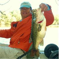
I think that Dan would be miffed at me if I failed to mention he caught the three pound, seven ounce lunker:

Happy, now, Dan? 
_________________
Don't forget to wear sunscreen and don't litter! |
|
| Back to top |
|
Dan1
Joined: 06 Sep 2013
Posts: 31
|
| Posted: Sun Sep 07, 2014 9:05 am Post subject: CT River |
|
|
Yes, but that was the 2lbs 7oz fish I caught later in the day. Had my hat off in the morning.  Unfortunately I don't think I have enough posts to post the picture. Unfortunately I don't think I have enough posts to post the picture. |
|
| Back to top |
|
PECo
Joined: 06 Oct 2009
Posts: 5203
Location: Avon, CT
|
| Posted: Sun Sep 07, 2014 9:52 am Post subject: |
|
|

Happy NOW?
_________________
Don't forget to wear sunscreen and don't litter! |
|
| Back to top |
|
Dan1
Joined: 06 Sep 2013
Posts: 31
|
| Posted: Sun Sep 07, 2014 5:27 pm Post subject: |
|
|
| Perfect! |
|
| Back to top |
|
PECo
Joined: 06 Oct 2009
Posts: 5203
Location: Avon, CT
|
| Posted: Sun Sep 07, 2014 9:09 pm Post subject: |
|
|
Hey, atrexontheboat. Have you considered getting detailed maps of the river above Hartford?
_________________
Don't forget to wear sunscreen and don't litter! |
|
| Back to top |
|
|
|
atrexontheboat
Joined: 01 Sep 2014
Posts: 12
Location: Canton, CT
|
| Posted: Sun Sep 07, 2014 11:06 pm Post subject: |
|
|
| yes I have. I have seen those maps offered for sale on the dep weekly fishing report. I usually use a site that gives all the lakes in ct and the depths. ive never seen the river this low. im going to try south out of the Hartford launch this week and try to get into crow point cove. nice pix by the way! |
|
| Back to top |
|
gdpalumbo
Joined: 29 Aug 2008
Posts: 3
|
| Posted: Thu Sep 18, 2014 4:20 pm Post subject: about those maps |
|
|
| If you have a mobile device, navionics has an app available that shows the river, all the depths and markers for like 15$. It also allows you to build routes and trip lengths with those routes.[/b] |
|
| Back to top |
|
gdpalumbo
Joined: 29 Aug 2008
Posts: 3
|
| Posted: Thu Sep 18, 2014 4:23 pm Post subject: about those maps |
|
|
| If you have a mobile device, navionics has an app available that shows the river, all the depths and markers for like 15$. It also allows you to build routes and trip lengths with those routes.[/b] |
|
| Back to top |
|
PECo
Joined: 06 Oct 2009
Posts: 5203
Location: Avon, CT
|
| Posted: Thu Sep 18, 2014 7:06 pm Post subject: |
|
|
I have the Navionics app on my iPhone. The Connecticut River chart ends well below the Bissell Bridge (aka the Route 291 Bridge).
_________________
Don't forget to wear sunscreen and don't litter! |
|
| Back to top |
|
|


